June 25, 2005

Baden Powell to Indian Arm Lookout, by David

A review of this hike will be posted soon.

Baden Powell to Indian Arm Lookout, by Magalie

This Saturday after getting my 4 wisdom teeth taken out, we decided to take advantage of the beautiful weather and to go for a quick hike. We opted for a hike in Deep Cove that we had done last summer with David's work and that we quite enjoyed.

deep cove
Deep Cove, where the rich live very well!

This hike starts at the very beginning of the extremely long Baden Powell Trail (aka, 47.7 km) and the section of our hike took us to Indian Arm Lookout: 4 km return, 165 m elevation, 2 hours with leisurely stop at the top.


The trail is in great condition, with real staircases and beautiful bridges. There are sections with many roots by it's nothing that affects the hike. This hike is very easy, with gentle elevation and the walk in the forest and over the many streams is quite beautiful.


Indian Arm lookout is a wonderful spot for a picnic, and I was sad that we did not bring a lunch (although with the surgery, I would not have been able to eat anything!). The view is spectacular although it is not nearly as high up as Mount St-Mark's summit. It is just a great spot to relax close to the city while feeling very far away.


Although I have said that this hike is short and easy, I did find it to be a little challenging this time around. With 3 different medications in my system, I found my energy level to be very low and that I was getting out of breath too easily. Thus, this hike can be done by anyone but might be a small challenge for some. Regardless, this is a great hike and it is worth the stop.

* Downside: you're not alone on the trail.
* Upside: short, easy, great view!

June 15, 2005

Lynn Loop Trail & Rice Lake Loop, by David

A review of this hike will be posted soon.

Lynn Loop Trail & Rice Lake Loop, by Magalie

Every summer, David's work organises hikes for its employees and their friends after work. With nice weather and long days blessing us, their hiking season has started. They usually do pretty good hikes, so I was quite happy to learn that.

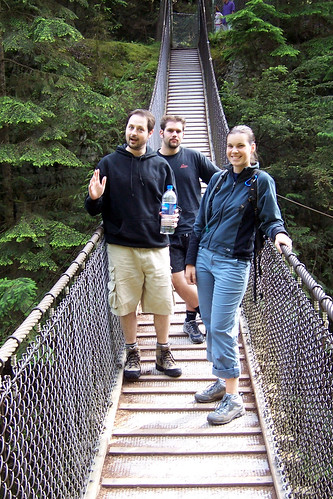
For their first hike it was decided at the very last minute that we would do a hike in Lynn Valley which is located in North Vancouver. We all met at the Lynn Canyon Park parking lot at around 6pm and started out on hour hike. (Park map)

That is, we all crossed the beautiful suspension bridge right off the lot which leads you to the trailhead. The bridge is the second suspension bridge in the region (the other being the Capilano suspension bridge) and while it is smaller and surely closer to the ground, it is free and less crowded. Capilano charges $25 for the thrill!!!

facing fear

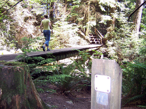
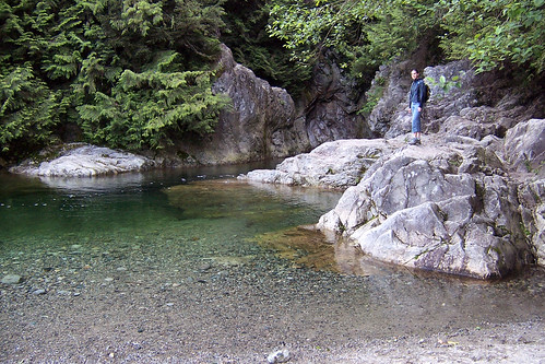
Once over the bridge, no one could decide if we should take the trail to the left, or to the right. Eventually, we chose the left side which follows the river and got walking. After an easy 15 minutes stroll, we arrived at the "30 foot pool", which is filled with beautiful clear water and with easy water access. A lovely spot to easy summer heat I am certain! (Although, please see note at bottom of post).

30 foot pool

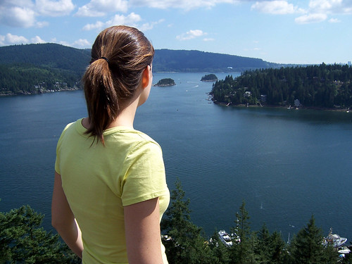
From here, the trail becomes a long staircase: this is the most challenging part of the trail, and by challenging, I mean that it was the only place where I broke a sweat. After the first set, there is a short second staircase and thereafter it is all flat terrain. Keep following the trail, and follow signs for Rice Lake Loop. Eventually you will reach the peaceful mirror-like lake and the fishing dock. If the place is not too busy with fishermen, this could be a very nice stop for a snack.

rice lake

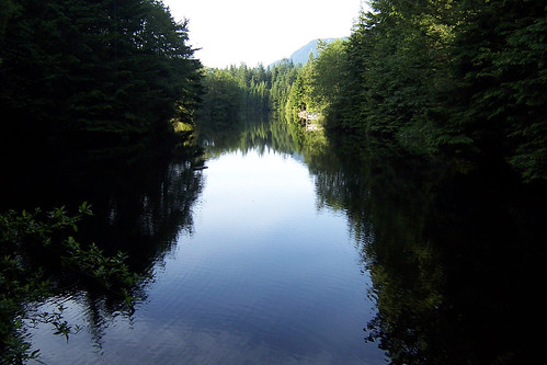
After a nice stop, return to the trailhead and head left to complete the loop. There are not many viewpoints of the lake but the few that occur are very beautiful. And this trail was very quiet!

Once the loop is completed, make your way back to the trail which brought you here. This time, instead of taking the stairs and seeing the pool again, do the trail the other way. The downhill trail is gentle and will complete the loop by taking you back to the bridge.

Overall I found this hike to be extremely easy. In fact, I would call this a walk, and not a hike. This walk would be a great idea in the winter time or when you just want to be in the forest, without effort. The walk is easy, smooth, and did not take us much more than an hour. If doing this hike with people with limited mobility or energy, skip the stairs and start the trail on the right-side after the bridge.

* Downside: Too easy! Too short!
* Upside: Quiet, beautiful river, beautiful lake, cool bridge. And easy!

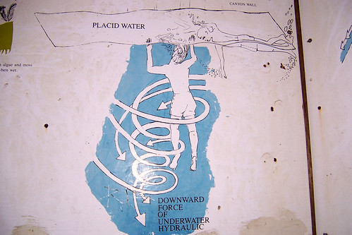
Note: The river in Lynn Park has caused the death and injury of many. Before the bridge, there is a very detailed panel advising hikers to not dive or swim in the river which explains how currents can trap you in numerous ways. Although they do not have any signs advising people to not enter the 30 Foot Pool, they do have an image of what could be that pool on the panel. Here is what it illustrates, so enter at your own risk (and yes, those are dead bodies):

nice and cheerful!

June 07, 2005

Grouse Grind, by David

On our way to the car, my friend Kendra asked "How fast can you run a 10km? Cause that's a good indicator of how long the Grind should take you."

The Grouse Grind, located on Grouse Mountain in North Vancouver, is probably Vancouver's most famous trail. It is notorious for being a steep and strenuous trail that takes you from the foot to the top of the mountain pretty much in a straight line. It is only 2.9km long, but the elevation change is a punishing 853m (2,800 feet). It was built illegally over 20 years ago by two men, Don McPherson and Phil Severy, without help or permission, and now sees more than 100,000 hikers every year.

Unfortunately the weather was poor and fog on the mountain would have prevented me from taking good pictures, so I left the camera home.

The trail starts in the parking lot underneath the Grouse Mountain gondola. The first part of the trail may not seem so bad, but the trail quickly becomes steeper. Rocks, dirt and wood are carefully placed to form steps. And the steps just keep coming. It is hard to enjoy the surroundings because you have to concentrate on where your feet land, and where to put them next. I turned around a few times, but the trees are so tall that even if there were no fog, I doubt there would be much to see from the trail. But it does make you appreciate how steep the trail is to take a peak back every once in a while.

At about the half-way marker, my legs were getting tired but I figured that if I stopped or slowed down, it would be a lot harder to pick up the pace so I kept going. As I kept climbing, it was starting to rain more, and I noticed the temperature drop because of the altitude change. You have to be a bit more careful with wet roots and steps when it rains as it can get slippery, but ropes are installed in the trickier sections to help prevent dangerous falls.

Maybe it's time to say that the Grouse Grind isn't for everyone. It is like climbing one and a half times the height of the CN Tower. I kept thinking that Mag would never enjoy this hike, and I was glad I did it without her first. Make sure you're in good shape and know what you're getting yourself into when you attempt to hike the Grind.

The trail at some point seems like it never ends since you can't see the top until you're there. When I reached the 3/4 marker, I was a bit shocked since I had been keeping track of my time and was expecting to be closer to the end. But the markers are apparently not exactly at the right spots. Since it was my first time on the trail, and I did not know exactly how much longer I had to go, I kept reminding myself that I was almost there and not to slow down. 10 minutes later large signs indicating the trailhead greeted me at the top. The fog was so thick I couldn't even see the pointy roof of the Peak Chalet that was 50 meters ahead.

I finished it in about 48-49 minutes, slightly better than my best 10km time. At the top you can hang out in the Peak Chalet and on a nice day, enjoy the view, but unfortunately there wasn't much to for us to see except fog. So we had a few drinks of water and paid the $5 for a gondola ride down the mountain back to the parking lot. The Grind is not really the kind of hike you do mostly for fun, it should be hiked more for the exercise or the challenge than anything else.

I'll do it again for sure.