Sigurd Creek to Crooked Falls, by David
This hike should have been planned better... We left too late, got lost on the way and by the time we got back to the car it was much too dark.
Directions:
Drive north to Squamish and turn left on Squamish Valley Road. Keep left at the fork about 3km onto the road. The road will turn into a gravel road after another 20km. Turn left onto the first bridge that crosses the Squamish River, there is a second bridge right after and stay on the main road. The guide advises not to take any possible right turns at that point. Then you will cross two more bridges over the Ashlu River. Look for a small road on your left after the second bridge, this is where you need to go (we kept going on the main road, the quality of which deteriorates past that point, you need a 4x4). You can park on the side of the main road and walk up for about 15 minutes to the trailhead, or, if you have a 4x4 truck you can have fun climbing the road. I have to say I had a great time driving my truck that day, thanks to 4-by.
Don't let the first part of the trail fool you, it will let you believe this is a flat and easy trail, but it will only be this way for about 10 minutes. Once you reach a small creek, the trails goes up the mountain and can be pretty slippery at points. The trail has steep, slippery sections and since it does not see a lot of trafic, some sections could need some maintenance. The trail is only a 6km round trip to Crooked Falls but one can hike past the falls to Sigurd Creek which is another 3km round trip but takes 2 hours according to the guide.
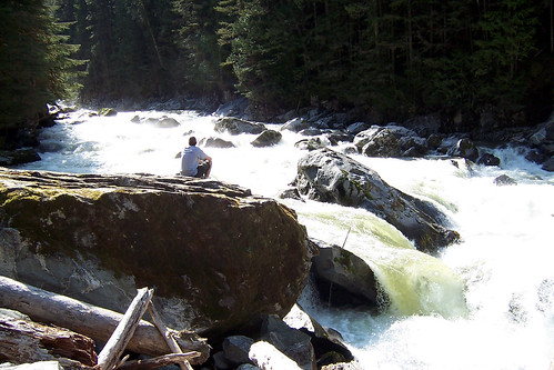
Since we hiked this trail early in the season and the snow is melting quickly, the falls were just raging. It was getting late and I had only brought a t-shirt so I rushed to take a picture without getting too wet because it was getting dark and chilly in the woods.
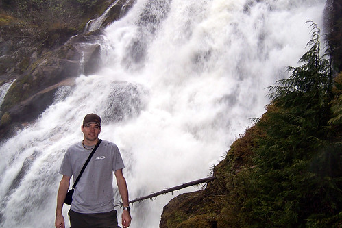
David getting wet for a picture at Crooked Falls.
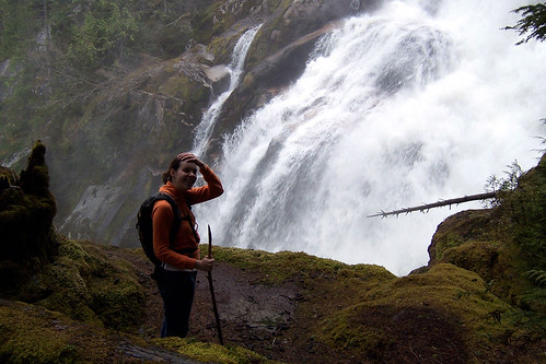
I thought the falls were very impressive and I was surprised of how close to the falls the trail takes you. You can hike down a bit the side of the falls but the thick cedars do prevent you from seeing more than small sections of the falls at the same time. You can only really see the top of Crooked Falls from that point and the view is very limited. In the summer when the falls aren't as strong, this must be a great spot to have lunch.
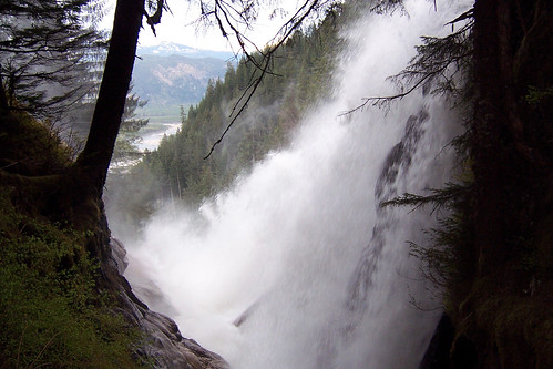
Crooked Falls
I personally enjoy a challenge and climbing does not scare me so contrarily to Magalie, I had a great time at Crooked Falls, I was not bothered by mosquitos, and would recommend it if you enjoy a more remote and slightly more challenging hike.
Directions:
Drive north to Squamish and turn left on Squamish Valley Road. Keep left at the fork about 3km onto the road. The road will turn into a gravel road after another 20km. Turn left onto the first bridge that crosses the Squamish River, there is a second bridge right after and stay on the main road. The guide advises not to take any possible right turns at that point. Then you will cross two more bridges over the Ashlu River. Look for a small road on your left after the second bridge, this is where you need to go (we kept going on the main road, the quality of which deteriorates past that point, you need a 4x4). You can park on the side of the main road and walk up for about 15 minutes to the trailhead, or, if you have a 4x4 truck you can have fun climbing the road. I have to say I had a great time driving my truck that day, thanks to 4-by.
Don't let the first part of the trail fool you, it will let you believe this is a flat and easy trail, but it will only be this way for about 10 minutes. Once you reach a small creek, the trails goes up the mountain and can be pretty slippery at points. The trail has steep, slippery sections and since it does not see a lot of trafic, some sections could need some maintenance. The trail is only a 6km round trip to Crooked Falls but one can hike past the falls to Sigurd Creek which is another 3km round trip but takes 2 hours according to the guide.
Since we hiked this trail early in the season and the snow is melting quickly, the falls were just raging. It was getting late and I had only brought a t-shirt so I rushed to take a picture without getting too wet because it was getting dark and chilly in the woods.
David getting wet for a picture at Crooked Falls.
I thought the falls were very impressive and I was surprised of how close to the falls the trail takes you. You can hike down a bit the side of the falls but the thick cedars do prevent you from seeing more than small sections of the falls at the same time. You can only really see the top of Crooked Falls from that point and the view is very limited. In the summer when the falls aren't as strong, this must be a great spot to have lunch.
Crooked Falls
I personally enjoy a challenge and climbing does not scare me so contrarily to Magalie, I had a great time at Crooked Falls, I was not bothered by mosquitos, and would recommend it if you enjoy a more remote and slightly more challenging hike.
posted by David Bhérer at 11:58 p.m.
2 comments
![]()
![]()